Any Activity
 Hiking
 Biking
 Horseback Riding
 Motorcycle Riding
 ATV Riding
 OHV Riding (>50”)
 Nordic Skiing
 Snowmobiling
 Snowshoeing Hiking Biking Horseback Riding Motorcycle Riding ATV Riding OHV Riding (>50”) Nordic Skiing Snowmobiling Snowshoeing
Please Note: The area represented on our map is not a perfect representation of the closure boundaries currently in place by Forest Service. Please refer to the attached map for the most detailed boundary. Contact the Routt National Forest for the most up-to-date information (which can be accessed from the link below).
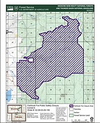
PROHIBITIONS Pursuant to 16 U.S.C. § 551 and 36 C.F.R. § 261.50(a) and (b), the following are prohibited on the National Forest System (NFS) lands, roads, and trails in the Hahns Peak-Bears Ears Ranger District, Routt National Forest, described below and shown on the attached map incorporated into this Order as Exhibit A (the “Described Area”): 1. Going into or being upon the Described Area. 36 C.F.R. 261.52(e) and 36 C.F.R. § 261.53(e). 2. Being on the Described Road. 36 C.F.R. § 261.54(e). 3. Being on the Described Trail. 36 C.F.R. § 261.55(a)
DESCRIBED AREA/ROADS/TRAILS The Described Areas eastern boundary is the Routt County/Grand County line from Hwy 40 north to NFST 1101. The area boundary on the north follows NFST 1101 west to NFST 1102 to NFST 1032 to Storm King Creek to the Routt National Forest Boundary (RNF). The area boundary on the west runs south along the RNF boundary to Hwy 40. The area boundary on the south follows Hwy 40 east to the Routt County/Grand County Line. Any roads and trails within this boundary are closed including NFSR 296.1 excluding Hwy 40, NFST 1101, NFST 1102, and NFST 1032.
PURPOSE The purpose of this Order is to protect public safety due to the impacts of the wildland fire and associated fire incident management activities.
A violation of the above prohibitions is punishable as a Class B misdemeanor by a fine of not more than $5,000 for individuals and $10,000 for organizations, or by imprisonment for not more than six months, or both.