Any Activity
 Hiking
 Biking
 Horseback Riding
 Motorcycle Riding
 ATV Riding
 OHV Riding (>50”)
 Nordic Skiing
 Snowmobiling
 Snowshoeing Hiking Biking Horseback Riding Motorcycle Riding ATV Riding OHV Riding (>50”) Nordic Skiing Snowmobiling Snowshoeing
UPDATE 07/28/2026:
Both the BLM and Forest Service have reduced the closure areas originally put in place in early July. We have updated our map to reflect this change.
On the southern end of the closure area, the Nellie Creek Road – FSR 7877, Nellie Creek Trailhead, Uncompahgre Peak Trail – NFST 9239, and Uncompahgre Peak is now open to the public.
—
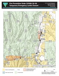
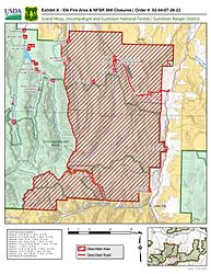
For the safety of firefighters and the public, the Grand Mesa, Uncompahgre and Gunnison National Forests’ Gunnison Ranger District as well as the Bureau of Land Management (BLM) Gunnison Field Office have enacted closure orders for areas adjacent to the Elk Wildfire.
Both closures restrict public access to all lands, roads and trails within the described area.
A map of the area and full USFS order details can be found here.
A map and description of the BLM closure order can be found here.
—
Please Note: The area represented on our map is not a perfect representation of the closure boundaries currently in place by the Forest Service and BLM. Please refer to the attached links and maps for the most detailed boundary.
Contact the Grand Mesa, Uncompahgre and Gunnison National Forests’ Gunnison Ranger District or the BLM Gunnison Field Office for the most up-to-date information.
A violation of this closure order is punishable as a Class B misdemeanor by a fine of not more than $5,000 for individuals and $10,000 for organizations, or by imprisonment for not more than six months, or both. 16 U.S.C. § 551; 18 U.S.C. §§ 3559, 3571, and 3581