Login
or
Sign Up
Home
Profile
Recorded Trips
Custom Routes
Field Notes
Trip Reports
Likes
Challenges
Following
Community Feed
+
+
COTREX is a project by the Colorado DNR and Colorado Parks and Wildlife.
About the Project
|
Donate
|
Contact
Terms
|
Privacy
|
About
Colorado Trail Explorer
Any Activity
Hiking
Biking
Horseback Riding
Motorcycle Riding
ATV Riding
OHV Riding (>50”)
Nordic Skiing
Snowmobiling
Snowshoeing
South Boulder Creek Trail
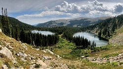
Trail
near
East Portal
Get Here
Like
Featured Routes
Crater Lakes via Moffat Tunnel East Portal
Featured Route
5.9mi
Roosevelt NF
Weather
View 7 Day Forecast on weather.gov
Trail Attributes
Total Length
4.6mi
Elevation Range
9,231–11,937ft
Δ
2,706ft
Manager
USFS Boulder Ranger District
URL
https://www.fs.usda.gov/recarea/arp/recarea/?recid=28346
2¾mi
https://www.fs.usda.gov/wps/portal/fsinternet/cs/recarea?ss=110308&navtype=BROWSEBYSUBJECT&cid=FSE_003738&navid=110240000000000&pnavid=110000000000000&position=generalinfo&recid=28346&ttype=recarea&pname=South%20Boulder%20Creek%20Trail
1¾mi
Trail Number
#900
Allows Hiking
Yes
Allows Dogs
Leashed
Allows Bikes
No
Allows Horses
Yes
Allows Motorcycles
No
Allows ATVs
No
Allows OHVs >50”
No
Allows Highway Vehicles
No
Surface
Dirt
Trip Reports
No trip reports yet
Write Trip Report
Login
or
Sign Up
Terms
|
Privacy
|
Legend
|
Help
Roads ©
OpenStreetMap
A project by
Colorado DNR
+
CPW
+
Natural Atlas